Monday 22 December 2014

Pottery with Tamil-Brahmini inscriptions, Berenike, Egypt, First Century A.D.

Pottery with Tamil-Brahmini inscriptions, Berenike, Egypt, First Century A.D.

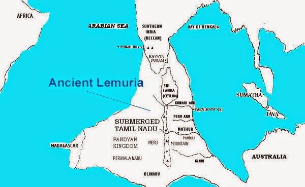
The ancient Tamil chief Korran ruled Kudiramalai between the 1st century BCE- late 1st century CE.


He was a commander in chief of the Chera Dynasty under the King Makkotai.
An avid horseman and great patron of poetry, Korran ruled from and administered the locality surrounding the ancient capital. He earned the epithet Kattuman Korran or "Horseman Korran" due to his love of horse riding. His father was Pittan, another famous Chera chief. His full name was sometimes credited as Pittan-Korran, following Tamil naming conventions detailed in the Tolkappiyam.
Korran oversaw the trade with Phoenicians, the Romans, the Seres and the Egyptians. Inscriptions in Tamil-Brahmi script from the 1st century BCE-1st century CE bearing his name (Korra-Puman - Korra The Chieftain) were excavated on an amphora fragment at the international Roman trading port of Berenice Troglodytica in present day Egypt. Korran's rule is described at length in the Purananuru and he is eulogised in several poems of Sangam literature. He ruled this area alongside two other chieftains, Elini Athiyamān Nedumān Añci and Kumanan. 

Chief Elini of Kudiramalai is described at length in the Purananuru and Akananuru. Kudiramalai was known as Hippuros, a famous port of the island to the ancient Greeks. The historian Pliny states that in the reign of the Emperor Claudius in 47 CE:
Samuel Bochart, a French biblical scholar, first suggested eastern localities for the ports of Ophir and Tarshish during King Solomon's reign, specifically the Tamilakkam where the local people were well known for their gold, pearls, ivory and peacock trade. He fixed on "Tarshish" being the site of Kudiramalai, a possible corruption of Thiruketheeswaram. The Classical Tamil names for ivory, apes, cotton cloth and peacocks which the Israelites imported from the Tamil country are preserved in Hebrew in the Hebrew bible.
Settlements of culturally similar early populations of ancient Sri Lanka and ancient Tamil Nadu in India were excavated at megalithic burial sites at Pomparippu on the west coast just south of Kudiramalai and in Kathiraveli on the east coast of the island. Bearing a remarkable resemblance to burials in the early Pandyan kingdom, these sites were established between the 5th century BCE and 2nd century CE. Kudiramalai shared a similar Tamil name with the equally bustling international port town of Northern Sri Lanka,Kandarodai-Kadiramalai of the Jaffna Peninsula. Other excavations have been conducted at Kudiramalai in the modern era; Bertolacci and Pridham refer to several ruins at the foot of the Kudiramalai hill and nearby Karaitivu island.
.....
In wide-ranging and ongoing excavations at Berenike launched from 1994 (and at many other places on the Eastern Desert), a team of dedicated archaeologists from the University of Delaware (United States) led by Prof. Steven E. Sidebotham (http://www.history.udel.edu/stevenside…/…/steven-sidebotham/) , along with partners from several other institutions, has documented evidence of the cargo from the Malabar coast and people from South India being at the last outpost of the Roman Empire and of Indians on the Berenike-Nile road.
Among the unexpected discoveries at Berenike were a range of ancient Indian goods, including the largest single concentration (7.55 kg) of black peppercorns ever recovered in the classical Mediterranean world (“imported from southern India” and found inside a large vessel made of Nile silt in a temple courtyard); substantial quantities of Indian-made fine ware and kitchen cooking ware and Indian style pottery; Indian-made sail cloth, basketry, matting, etc. from trash dumps; a large quantity of teak wood, black pepper, coconuts, beads made of precious and semi-precious stones, cameo blanks; “a Tamil Brahmi graffito mentioning Korra, a South Indian chieftain”; evidence that “inhabitants from Tamil South India (which then included most of Kerala) were living in Berenike, at least in the early Roman period”; evidence that the Tamil population implied the probable presence of Buddhist worshippers; evidence of Indians at another Roman port 300 km north of Berenike; Indian-made ceramics on the Nile road; a rock inscription mentioning an Indian passing through en route; “abundant evidence for the use of ships built and rigged in India”; and proof “that teak wood (endemic to South India), found in buildings in Berenike, had clearly been reused”(from dismantled ships).
.....
During the Pharaonic era , trading concentrated on the Red Sea on the coast of East Africa. From the Ptolemies (300 v . Chr . ) Drove the Egyptians to southern Arabia and from Roman times to India and Sri Lanka. In Arikamedu , an Indian port , Roman pottery and coins have been found during excavations at Berenike and El Quseir - Qadim promoted Indian Jars , Tamil inscriptions and products from the Far East to days . During the Mameluken- and Ottomanenherrschaft the Red Sea has played a key position for the Mediterranean trade with Asian luxury goods.
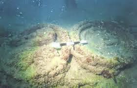
In the site The Quseir shipwreck is what remains of an ancient Roman shipwreck located at Quesir which dates from between the 1st century B.C. and the 1st century A.D. It is believed to have belonged to Emperor Augustus and may have been on an outbound voyage to India.
Excavation of the harbor and former settlement at Quseir EL-Qadim have provided indicators pointing towards trade with India.
.....
Pottery with Tamil-Brahmini inscriptions, Berenike, Egypt, First Century A.D.
.....
எகிப்து நாட்டில் தமிழர் பானை (கொற்றப்பூமான்)
கொற்றப்பூமான் என்னும் பெயர் பொறித்த இலங்கை நாட்டு தொல்பொருள் கெய்ரோ காட்சியகத்தில் உள்ளது.
எகிப்து, தாய்லாந்து ஆகிய வெளிநாடுகளில் மேற்கொண்ட அகழ்வாய்வுகளில் பண்டைய தமிழ் எழுத்துக்கள் பொறிக்கப்பட்ட பானையோட்டுச் சில்லுகள் கிடைத்துள்ளன.
எகிப்து நாட்டுப் 'பெரெனிகே' துறைமுகத்தில் கண்டெடுக்கப்பட்டுள்ள பானையோட்டுச் சில்லு இது.
இதில் கொ ற் ற பூ மா ன் என்னும் எழுத்துக்கள் உள்ளன. இவற்றில் [ற], [ன] ஆகிய எழுத்துக்கள் தமிழுக்கு மட்டுமே உரிய சிறப்பு எழுத்துக்கள்.
கொற்ற பூமான் பயன்படுத்திய பானை இது. இவன் எகிப்து நாட்டுக்குச் சென்று வாணிகம் செய்திருக்கிறான்.
எகிப்து நாட்டில் செங்கடல் பகுதியில் லெய்டன் பல்கலைக்கழகத்தார் நடத்திய அகழ்வாராய்ச்சியில் 'கொற்ற பூமான்' என்ற சங்ககாலத் தமிழி எழுத்துக்கள் பொறித்த மதுச்சாடி கிடைத்துள்ளது. இவையிரண்டும் கி.பி. முதல் நூற்றாண்டைச் சேர்ந்த எழுத்துப் பொறிப்புக்கள் ஆகும்.
.....

Thursday 18 December 2014

Kumari Kandam - The Lost Tamil Continent

Kumari Kandam- The Lost Continent


Kumari Kandam is the legendary sunken continent, according to many of the ancient extant Tamil literatures and some of the Sanskrit literatures. Almost 100 years back tamil nationalists came to identify and associate Kumari Kandam with Lemuria, a hypothetical “lost continent” posited in the 19th century to account for discontinuities in biogeography.

Located in the Indian and Pacific Oceans but now sunken, t
his sunked continent is believed to be the connections between Africa to South India, through Madagascar.
Many of the earliest extant Tamil literary works and their commentaries, mentions a Tamil continent called Kumari Kandam, which was ruled by Pandiyan Kings for 9,990 years, before getting submerged in the Indian Ocean, south of present-dayKanyakumari district at the southern tip of India.
References of Kumari Kandam from some of the Tamil literary sources
According to Silappadhikaram, one of the Five Great Epics of Tamil Literature written in 2nd century CE, states that the cruel sea took the Pandiyan’s land, part of which was present between the rivers Pahruli and the mountainous banks of the Kumari. These rivers are said to have flowed in a now-submerged land.

Adiyarkkunallar, a 12th-century CE commentator on the epic, explains this reference by saying that there was once a land to the south of the present-day Kanyakumari, which stretched for 700 kāvatam from the Pahruli river in the north to the Kumari river in the south. The modern equivalent of the measurement kāvatam, which is also known askātam in Tamil, is a distance of 6.25 miles (10.06 km).

Kanakkathikaram, a 15th century Tamil Mathematical literary work which is in the form of poems, defines the length of 1 kāvatam(1 kātam) as 24,000 muzham (33,000 feet, 6¼ miles) and it also defines the time taken to cover it which is the distance that can be covered by normal walk in 7½ Nāzhigai or 1 Sāmam (equivalent to 3 hours). So, the distance of 700 kāvatam is equivalent to 4,375 miles (7,041 km) in modern day measurements.

This land was divided into 49 territories, which he names as 
Seven coconut territories (elutenga natu), 
Seven Madurai territories (elumaturai natu), 
Seven old sandy territories (elumunpalai natu), 
Seven new sandy territories(elupinpalai natu), 
Seven mountain territories (elukunra natu), 
Seven eastern coastal territories (elukunakarai natu) and 
Seven dwarf-palm territories(elukurumpanai natu). 

All these lands, he says, together with the many-mountained land that began with KumariKollam, with forests and habitations, were submerged by the sea. Two of these  territories were supposedly parts of present-day Kollam and Kanyakumari districts.
The 7th century CE commentary written by Nakkīranār for the Tamil literary work Iraiyanar Akapporul, gives the list of Pandiyan kings who ruled the Kumari Kandam. It also gives information about the three Tamil Sangams (assemblies of Tamil scholars and poets who do research on Tamil language and also creates literary works) which spans about 9,990 years.
According to this commentary, out of three Tamil Sangams, first two happened in Kumari Kandam.

Also, according to this commentary:
The First Sangam (Mutaṟcaṅkam) is described as having been held at the Pandiyan King’s capital city, Madurai (Kadal Konda Then Madurai – which means Southern Madurai which was submerged in the sea. 
The old Madurai was called as Southern Madurai to differentiate it with the capital city of Madurai of third Sangam), which lasted a total of 4440 years, and had 549 members, which supposedly included some gods of the Hindu pantheon such as SivaKubera and Murugan.
A total of 4449 poets are described as having composed songs for this Sangam. 
There were 89 Pandiyan kings starting from Kaysina valudi to Kadungon were decedents and rulers of that period.
If credence is given to this commentary, then the beginning of first Sangam should be placed somewhere in 9000 B.C.

Most of the lands of Kumari Kandam were submerged in the sea during first devouring of the land by the sea. Then, the Pandiyan King and the remaining people migrated to the remaining land of Kumari Kandam and the king moved his capital toKapatapuram. At the same time, the present location of Tamil Nadu was ruled byCheraChola, and 46 other small kingdoms.
The Second Sangam (Irandaam Caṅkam, Iṭaicaṅkam) was convened in Kapatapuram, the then capital city of Pandiyan King. This Sangam lasted for 3700 years and had 59 members, with 3700 poets participating. There were 59 Pandiyan kings starting from Vendercceliyan to Mudattirumaran were decedents and rulers of that period.

This city was also submerged in sea. Ramayana and Arthasastra of Kautalya corroborates the existence of a city named kavatapuram. There is a reference to a south Indian place called kavata by sugriva in a verse which runs something like ‘having reached Kavata suitable for Pandiya‘. The place kavata is also mentioned by Kautalya (also known as Acharya Chanakya) in Arthasastra.
Having lost the complete Kumari Kandam, the Pandiyan King conquered the part of lands belonging to the Chola and Chera kings (Silapathikaram, Maturaikkandam, verses 17-22) and made Korkai, a seaport on the southernmost tip of the Indian Peninsula, as his capital and in later times moved his capital to the current city of Madurai.
The Third Sangam (Moondraam Caṅkam, Kaṭaicaṅkam) was purportedly located in the current city of Madurai, the then capital city of Pandiyan King, and lasted for 1850 years. There were 49 Pandiyan kings starting from Mudattirumaran (who came away from Kabadapuram to present Madurai) to Ukkirapperu valudi were decedents and rulers of that period.
The academy had 49 members, and 449 poets are described as having participated in the Sangam.
map of lemuria or Kumari kandam in Indian ocean
Map of Lemuria or Kumari kandam in Indian ocean

References of Kumari Kandam in Puranas and Ancient Tamil Literature

Bhagavata-Purana, 10th Skanda.

  • In Tamil literature works AintiramSilappadhikaram,Manimekhalai and Saivam Paayanam and in Sanskrit literary work Bhagavatha Purana, there are information about Tamil sage Mayan, who wrote one of the Tamil Sangam literary works Aintiram, and was part of Tamil Sangams and lived in Kumari Kandam.

  • This sage also wrote other Tamil literature Pranava Vedham (which is called by Vyasa as the predecessor of four Vedas in Bhagavatha Purana), Maya Matham (Book about Architecture, Sculptures and Vasthu) and Suriya Nool (Book about Astronomy and Astrology), one Tamil grammatical work, etc. According to Aintiram, Kumari Kandam was a land which has huge area and the PalThuli river (PalThuli – Divided grammatical form of Pahruli according to Tamil grammar which means many drops), one of the Kumari Kandam rivers, originated from PeruMalai(means big mountain – represents MeruMalai – Meru Mountain). It also tells that there were 49 lands in Kumari Kandam.
    Tamil literary work SaivamPaayanam gives information about Kumari Kandam and its territories. It also mentions the existence of Peru Malai (MeruMalai – Meru Mountain) in Kumari Kandam.
  • The Tamil literary work Manimekhalai, mentions about multiple Tsunamis in the ancient city of Poompuhar and was swallowed up by the sea. This event is supported by archeological finds of submerged ruins off the coast of modern Poompuhar.
  • The Tamil poetic literature Tamil vidu thoothu describes the Topography of Kumari Kandam. It is also said that the Pahruli river was excavated to irrigate the mountain valley by the Pandiyan King Nediyon.
    The third Sangam literary work Purananooru talks about Kumari Kandam and the river Pahruli which was there in Kumari Kandam.
  • The Tamil Grammar work Nannool talks about the sunken country Kumari Kandam.
  • The Tamil literature SiruKakkaip Paadiniyaar talks about the Kumari Kandam.
  • There are references for Kumari Kandam present in Kantapuranam, which mentions it as one of the nine continents of old times, or one of the nine divisions of India and the only region not to be inhabited by barbarians.
  • According to the Matsya PuranaManu was the king of Dravidadesa (South Indian country) in Kumari Kandam.
  • There are references for Kumari Kandam present in Garuda Puranam. Also, There are scattered references in Sangam literature, such as Kalittokai 104, to how the sea took the land of the Pandiyan Kings, after which they conquered new lands to replace those they had lost.

References of Kumari Kandam (Lemuria) in Chinese & Greek Literature
In some of the ancient Chinese chronicles, there are references to Pahruli riverPeru river and Meru Mountain (with 49 peaks) from where the Kumari River, Peru river and Pahruli river were originated (according to Tamil literature). It is said that Chinese laborers were employed by the Pandiyan King and when they went down the mines they appeared like a huge army of small ants. Therefore, they were called pon thondi erumbukal (Gold mining ants). This is also confirmed by ancient Chinese chronicles.
Megasthenes (ca. 350 – 290 BCE), a Greek ethnographer and explorer in the Hellenistic period, authored the work Indika, the account of his travels in India. In this work, he says that Taprobane (old name of Sri Lanka) was separated from the mainland (Indian Peninsula) by a river, which means that during the period of Megasthenes, Sri Lanka could have been connected to Indian Peninsula by a small landmass in between them and was divided by Thamirabarani River (Porunai River).

The current Thamirabarani River in Tamil Nadu flows into the sea suggests that the Thamirabarani River would have reached Sri Lanka through a now-submerged landmass existed between Indian Peninsula and Sri Lanka during the period of Megasthenes.
Archaeological Data supporting existence of Kumari Kandam
remains found of kumari kandam
archeological findings at Poompuhar
  • The marine archeological findings at Poompuhar (Tamil Nadu) by marine archeological research conducted by the National Institute of Marine Archeology (Goa) reveals that much of the town of Poompugar (Tamil Nadu) was washed away by progressive erosion and a Tsunami around 300 BC.
  • Ancient Pottery dating back to the 4th century BC have been discovered off shore by marine archeologists east of this town. The timeline of this Tsunami also coincides with the timeline (after the period of Megasthenes visit to India) of the submergence of landmass which was claimed to be existed between Indian Peninsula and Sri Lanka according to Megasthenes accounts.
  • The geological survey reveals that most of the places in the land under the sea, where Kumari Kandam is claimed to be existed, has the maximum depth of the sea of 200 meters. In some of the places, the maximum depth of the sea is 2000 meters. Since, these areas has low sea depth, there are more possibilities to exists a now-submerged land in which people lived.
  • Languages spoken by Australian tribes, African tribes, Andaman and Nicobartribes and Lakshadweep tribes are identical to Tamil language. So, there are high possibilities that there might be a connecting land which exists in between India, Australia and Madagascar
  • Types of plants, trees and animals present in Africa and Madagascar are identical with that of in India. So, there might be a connecting land which exists in between India and Madagascar.

Expedition to Poompuhar – Remains of Kumari Kandam